

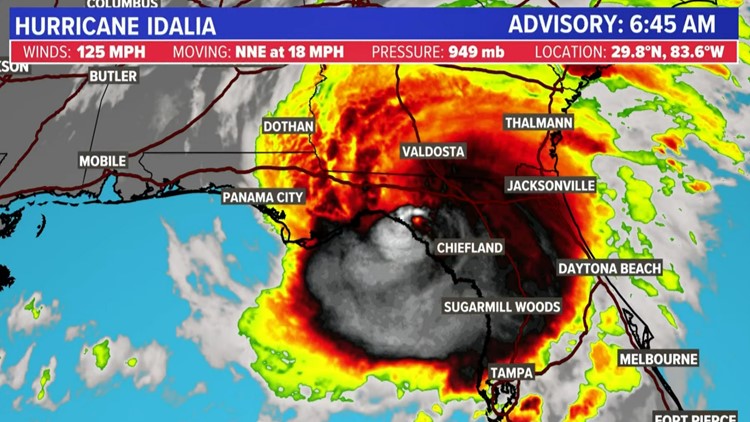
HOUSTON — Idalia made landfall Wednesday morning as a Category 3 hurricane in the Big Bend area of Florida with "catastrophic and life-threatening" impacts, according to the National Hurricane Center.
The storm made landfall at about 6:45 a.m. CT The storm briefly strengthened into a Category 4 storm early Wednesday but was downgraded back to a Category 3 before landfall.
With the 6 a.m. update, Hurricane Idalia had winds at 125 miles per hour. It was moving to the north at 18 miles per hour.
Hurricane Idalia watches and warnings

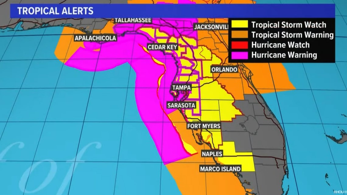
- A Storm Surge Warning is in effect for Englewood northward to Indian Pass, including Tampa Bay and St. Catherine's Sound to South Santee River
- A Hurricane Warning is in effect for the middle of Longboat Key northward to Indian Pass, including Tampa Bay.A Tropical Storm Warning is in effect for Chokoloskee northward to the Middle of Longboat Key, west of Indian Pass to Mexico Beach, Sebastian Inlet Florida to Surf City North Carolina.
- A Storm Surge Watch is in effect for Bonita Beach northward to Englewood, including Charlotte Harbour, the mouth of the St. Mary's River to St. Catherine's Sound Georgia, Beaufort Inlet to Ocracoke Inlet North Carolina and Neuse and Pamlico Rivers North Carolina.
- A Hurricane Watch is in effect for the mouth of the St. Mary's River to Altamaha Sound and Edisto Beach to South Santee River.
What is a Hurricane Warning?
A Hurricane Warning means that hurricane conditions are expected somewhere within the warning area. Preparations to protect life and property should be rushed to completion.
What is a Storm Surge Warning
A Storm Surge Warning means there is a danger of life-threatening inundation, from rising water moving inland from the coastline, during the next 36 hours in the indicated locations. This is a life-threatening situation. Persons located within these areas should take all necessary actions to protect life and property from rising water and the potential for other dangerous conditions. Promptly follow evacuation and other instructions from local officials.
What is a Tropical Storm Warning?
A Tropical Storm Warning means that tropical storm conditions are expected somewhere within the warning area.
What is a Storm Surge Watch?
A Storm Surge Watch means there is a possibility of life-threatening inundation, from rising water moving inland from the coastline, in the indicated locations during the next 48 hours.
What is a Hurricane Watch?
A Hurricane Watch means that hurricane conditions are possible within the watch area.
What is a Tropical Storm Watch?
A Tropical Storm Watch means that tropical storm conditions are possible within the watch area, generally within 48 hours.
No impact for the Texas coast
Even though the Texas coast isn't expecting any impacts from this moisture source (would be nice, we need the rain), we are continuing to monitor. This time of year things can rapidly change.
The reason we won't see anything from this is that we have a weak front on the way. This boundary will help as an upper-level steering current and push the moisture and any development to our east. That will hug the Florida coastline around Tuesday/Wednesday next week.
Check our live tropical loop, showing forecast track, models and more
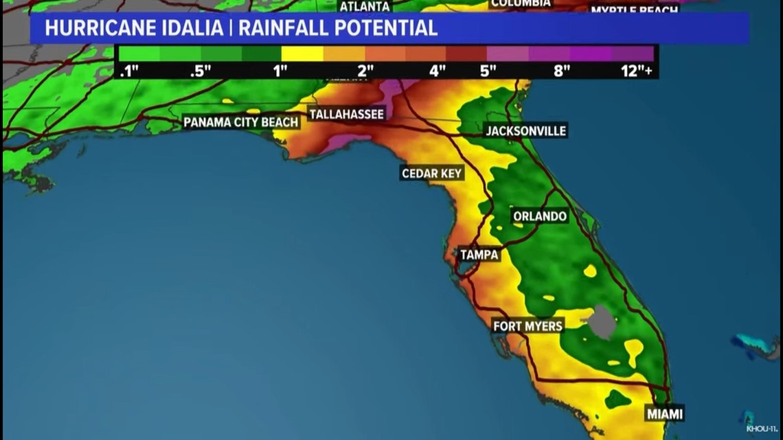
Hurricane Idalia rainfall
Idalia is expected to produce a swath of 4 to 8 inches of rainfall with isolated maxima of up to 12 inches from the Florida Big
Bend through central Georgia and South Carolina, and through eastern North Carolina into Thursday. These rainfall amounts will lead to areas of flash, urban, and moderate river flooding, with considerable impacts.


Hurricane Idalia storm surge
The combination of storm surge and tide will cause normally dry areas near the coast to be flooded by rising waters
moving inland from the shoreline. The water could reach the following heights above ground somewhere in the indicated areas if the peak surge occurs at the time of high tide:
- Wakulla/Jefferson County, FL to Yankeetown, FL...12-16 ft
- Ochlockonee River, FL to Wakulla/Jefferson County, FL...8-12 ft
- Yankeetown, FL to Chassahowitzka, FL...7-11 ft
- Chassahowitzka, FL to Anclote River, FL...6-9 ft
- Carrabelle, FL to Ochlockonee River, FL...5-8 ft
- Anclote River, FL to Middle of Longboat Key, FL...4-6 ft
- Tampa Bay...4-6 ft
- Indian Pass, FL to Carrabelle, FL...3-5 ft
- Middle of Longboat Key, FL to Englewood, FL...3-5 ft
- Saint Catherines Sound, GA to South Santee River, SC...3-5 ft
- Englewood, FL to Bonita Beach, FL...2-4 ft
- Beaufort Inlet, NC to Ocracoke Inlet, NC...2-4 ft
- Mouth of the St. Mary's River to Saint Catherines Sound, GA...2-4 ft
- Charlotte Harbor...2-4 ft
- Neuse and Bay Rivers...2-4 ft
- Pamlico and Pungo Rivers...2-4 ft
- Flagler/Volusia County Line, FL to Mouth of the St. Mary's
- River...1-3 ft
- Mexico Beach, FL to Indian Pass, FL...1-3 ft
- Bonita Beach, FL to East Cape Sable, FL...1-3 ft
- South Santee River, SC to Beaufort Inlet, NC...1-3 ft
- Ocracoke Inlet, NC to Duck, NC...1-3 ft
The deepest water will occur along the immediate coast near and to the right of the center, where the surge will be accompanied by large and destructive waves. Surge-related flooding depends on the relative timing of the surge and the tidal cycle and can vary greatly over short distances. For information specific to your area, please see products issued by your local National Weather Service forecast office.
2023 Atlantic hurricane season predictions
The National Oceanic and Atmospheric Administration recently doubled the chances of a nasty Atlantic hurricane season this summer and fall.
The agency said there's a 60% chance for an above-normal hurricane season, twice the agency's May forecast which said it was 30%. The earlier forecast leaned more toward a near-normal season with a 40%, but the chance for normal has now shrunk to 25%.
Although the NOAA outlook doesn’t forecast storm tracks or what places will get hit, a busy season like the one forecast means “there is a doubling of the chance of a hurricane making landfall on the East Coast of the U.S.,” said Matthew Rosencrans, lead hurricane season forecaster with NOAA’s Climate Prediction Center.
NOAA is now forecasting between 14 to 21 named storms, which is an increase over forecasters' initial May forecast of 12 to 17. A normal year has 14 named storms.
Of those named storms, NOAA predicts six to 11 will become hurricanes, which is more than the five to nine predicted in May. Normal is seven hurricanes. Of those hurricanes, NOAA predicts two to five will become major hurricanes with winds of more than 110 mph, which is one more than earlier predictions. A normal year sees three major hurricanes.
Follow the KHOU 11 Weather Team to stay up-to-date on the local forecast and what's brewing in the tropics: